Wall Cloud
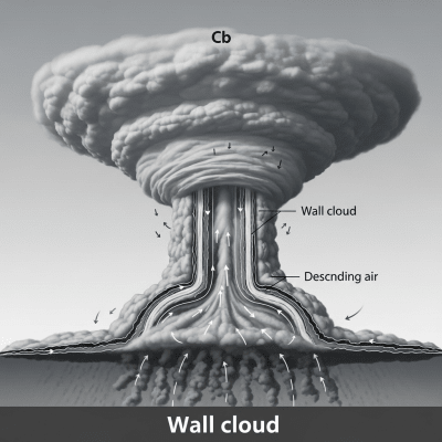
A wall cloud is a sharply lowered, localized cloud formation beneath a cumulonimbus base, signaling intense storm updrafts and often preceding tornado development.
A wall cloud is a sharply lowered, localized cloud formation beneath a cumulonimbus base, signaling intense storm updrafts and often preceding tornado development.
The term "wall cloud" emerged in mid-20th century American meteorology, describing the distinctive "wall-like" lowered cloud beneath severe thunderstorms. Formalized in the International Cloud Atlas and severe storm literature, it identifies a key accessory feature of powerful cumulonimbus storms.
Wall clouds are classified as accessory clouds associated with cumulonimbus (Cb) mother clouds. They are not a genus or species but a supplementary feature marking the storm's inflow region and updraft, recognized by the World Meteorological Organization.
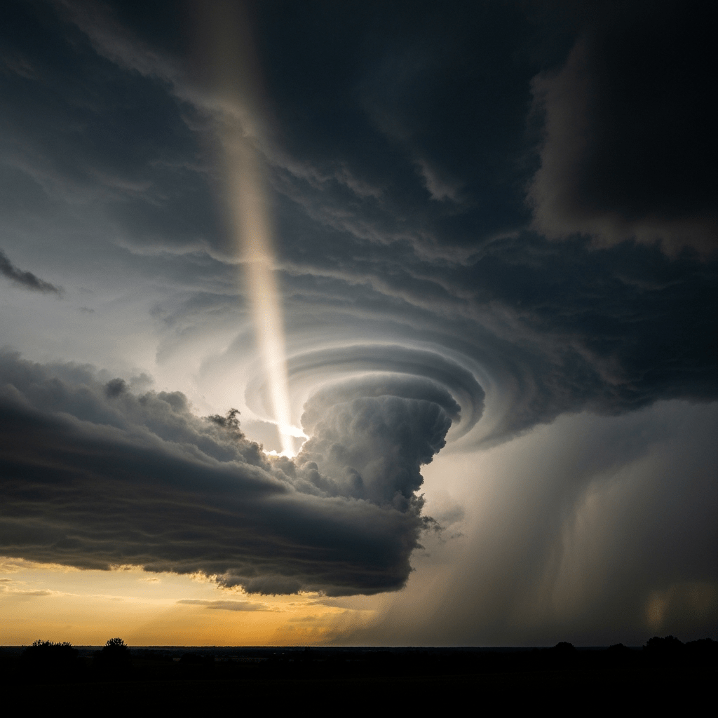
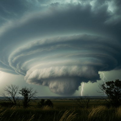
Wall clouds appear as cylindrical, blocky, or wedge-shaped vertical masses sharply lowered below the main cumulonimbus base. They can span from hundreds of meters to several kilometers horizontally and often exhibit a dark gray color, sometimes with a greenish tint caused by hail or moisture.
Forming where warm, moist air rapidly ascends into a storm's updraft, wall clouds mark the boundary between rain-cooled air and inflow regions. Their rotation and lowering often indicate storm intensification, serving as critical visual cues for meteorologists and storm spotters assessing tornado risk.
Bring this kind into your world � illustrated posters, mugs, and shirts.

Archival print, museum-grade paper
Buy Poster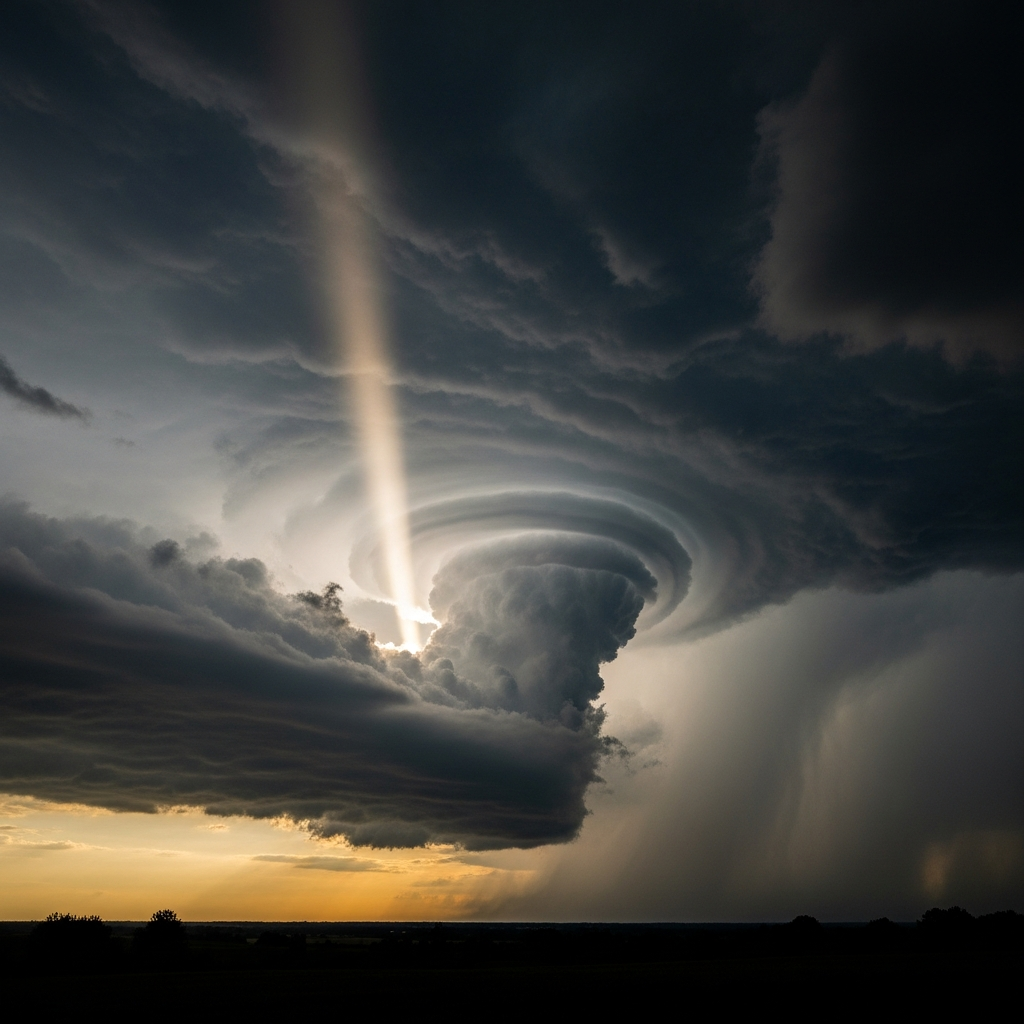
Stoneware mug, dishwasher safe
Buy Mug
Soft cotton tee, unisex sizes
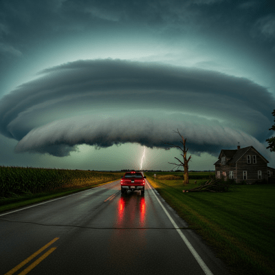
Buy ShirtWall clouds hold iconic status in storm photography and severe weather education, symbolizing the raw power of thunderstorms and tornado genesis. They feature prominently in public safety campaigns and have become emblematic of tornado-prone regions, especially in the United States.
Wall clouds form as warm, moist air is drawn into a thunderstorm's updraft, rapidly cooling and condensing. This process lowers the cloud base sharply where the strongest inflow meets the storm's updraft, often marking the boundary between rain-cooled downdraft air and the inflow region. In supercell storms, rotation (mesocyclone) may develop within the wall cloud, signaling intensification.
Typically found at altitudes between 500 and 2000 meters above ground, wall clouds occur within the vertical extent of cumulonimbus clouds. They are most common in mid-latitude continental regions prone to severe convection, notably the central United States' Tornado Alley, but can develop worldwide wherever strong thunderstorms arise.
Wall clouds are closely linked to severe weather hazards including tornado genesis, damaging winds, hail, and flash flooding. They serve as vital visual warnings for tornado formation, guiding safety measures and emergency responses. Observers should maintain caution and seek shelter if a wall cloud exhibits rapid rotation or lowering.
Wall clouds are primarily observed visually by storm spotters and meteorologists using ground-based photography and direct observation. Radar technology detects associated rotation and storm structure, while drones and mobile platforms increasingly aid in detailed study. Satellite sensors generally cannot resolve wall clouds directly due to their small size and low altitude.
Due to their limited size and low altitude, wall clouds do not appear distinctly in satellite imagery. Their presence is inferred from broader storm signatures, such as cumulonimbus cloud tops and radar-detected rotation, rather than direct optical or infrared satellite detection.