
Cumulus congestus
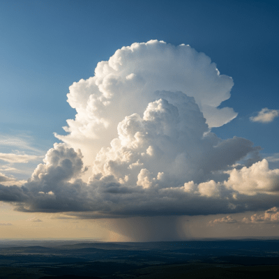
Cumulus congestus is a towering species of cumulus cloud characterized by its strong vertical growth and cauliflower-like appearance, often signaling atmospheric instability and the potential for developing thunderstorms.
Cumulus congestus is a towering species of cumulus cloud characterized by its strong vertical growth and cauliflower-like appearance, often signaling atmospheric instability and the potential for developing thunderstorms.
The name Cumulus congestus derives from Latin, with "cumulus" meaning "heap" and "congestus" meaning "piled up." First described in the 19th century amid evolving cloud classification efforts initiated by Luke Howard, this species was formalized by the World Meteorological Organization as an intermediate stage between fair-weather cumulus and thunderstorm-producing cumulonimbus clouds.
Cumulus congestus belongs to the genus Cumulus and is recognized as a distinct species, congestus. It represents a vertical development stage within the cumulus family, positioned between the smaller, fair-weather cumulus species and the fully developed cumulonimbus thunderstorm clouds. In aviation, it is commonly reported as "TCU" (Towering Cumulus).
Cumulus congestus clouds exhibit pronounced vertical growth, resembling towering cauliflower heads or turrets. Their bases are typically flat and dark gray, contrasting sharply with bright white, sharply contoured tops that may form domes or multiple turret-like protrusions. These dense, well-defined clouds often appear dense and textured, with occasional smooth cap clouds (pileus) or thin veils (velum) crowning their summits.
These clouds form as warm, moist air rises vigorously through unstable atmospheric layers, condensing into rapidly growing vertical structures. Cumulus congestus serves as a key indicator of convective activity and atmospheric instability, often preceding thunderstorm development. Meteorologists and aviators monitor them closely for signs of turbulence and precipitation, as they can produce moderate showers and localized weather hazards.
Bring this kind into your world � illustrated posters, mugs, and shirts.

Archival print, museum-grade paper
Buy Poster
Stoneware mug, dishwasher safe
Buy Mug
Soft cotton tee, unisex sizes
Buy ShirtCumulus congestus clouds have long captured the imagination as classic "towering cumulus" formations, frequently featured in weather photography, art, and educational materials. Their dramatic shapes symbolize the dynamic power of the atmosphere and are often associated with the anticipation of changing weather, making them iconic in meteorological culture and popular imagery.
🌦️ Cumulus congestus forms through strong convective processes in unstable air masses. Warm, moist air near the surface rises rapidly in thermals, cooling adiabatically until condensation occurs. This condensation releases latent heat, further fueling upward motion and leading to rapid vertical growth. The cloud base remains relatively flat where condensation begins, while the top develops turret-like structures as the air continues to ascend. Supplementary features such as pileus caps may form when moist air is lifted over the cloud top, and precipitation may begin as droplets coalesce in the upper regions.


🗺️ Typically classified as a vertical cloud, Cumulus congestus bases range from approximately 500 to 2,000 meters above ground level, with tops extending from 2,000 up to 6,000 meters or more, especially in tropical climates. They are common across tropical, temperate, and continental regions, frequently appearing during periods of strong surface heating or frontal instability that promote vigorous convection.
⚠️ While not as severe as cumulonimbus clouds, Cumulus congestus can produce moderate to heavy showers, localized turbulence, and icing hazards at higher altitudes due to supercooled water droplets. These conditions can impact aviation safety by reducing visibility and causing aircraft instability. Pilots are advised to avoid flying through or near these clouds when possible.
🔍 Observation of Cumulus congestus is commonly performed visually by meteorologists and pilots, noting their distinctive towering shape. Ceilometers and radar provide vertical profiling to measure cloud base and top heights and internal structure. Satellite remote sensing, using visible and infrared bands, helps identify their bright, sharply contoured tops and cold cloud temperatures, aiding in tracking development and spatial distribution.
🛰️ In satellite imagery, Cumulus congestus appears as bright white, sharply defined clouds with pronounced vertical shadows in visible wavelengths, highlighting their towering structure. Infrared sensors detect their relatively cold cloud tops compared to surrounding air, indicating significant vertical extent. These signatures help distinguish them from flatter cumulus species and track convective activity.